Why we monitor the seismic activity?
Monitoring the seismicity of Romania's territory is one of the important objectives of the INCDFP, with the main purpose of detecting and locating in the shortest possible time all seismic events (earthquakes, explosions) produced on the territory of Romania. This information is quickly sent to inform authorities, emergency inspectorates, the media and the public, and in the case of strong earthquakes, to alert these institutions to a particularly important disaster in the event of an earthquake disaster.
Monitoring seismic networks
National Seismic Network of Romania
The main purpose of RSN is to monitor the Romanian territory from a seismic point of view and to provide data of the best quality for studying the seismic source, the study of the internal structure of the Earth, for microzone studies and seismic hazard, but also for the exchange data with international seismic data centers. RSN consists of digital seismic stations that record continuous motion of land (real-time stations - 125) and stations that record ground movement only when it exceeds a preset value (trigger stations - 16). The data recorded by RSN are transmitted to the INCDFP headquarters where they are processed and analyzed 24 hours / 7 days a week by service seismologists.
Earthquakes registered in Romania are cataloged and published on the INCDFP website. The information presented refers to the date and time of the earthquake, the location (latitude, longitude, depth) and its magnitude (ML - local magnitude). Also, recorded data contributes to the creation of international seismic bulletins.
In the case of earthquakes with magnitude greater than 3 and intermediate earthquakes with magnitude greater than 3.5, the data recorded by RSN is used to produce maps useful to post-earthquake intervention (ShakeMaps).
RSN is composed of:
Short real time network in real time
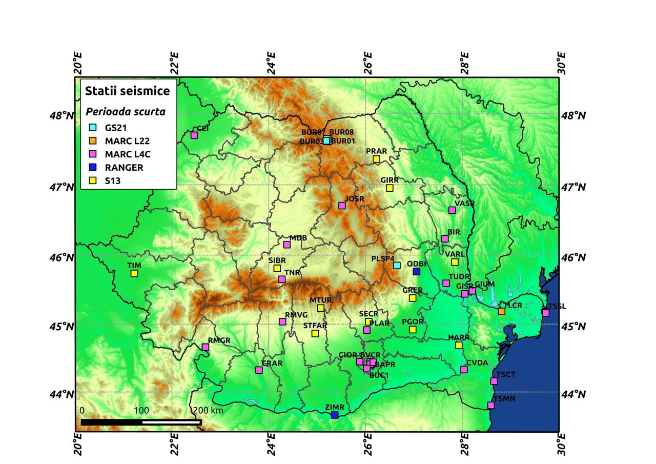
Between 1980 and 1982 was installed the first network of stations equipped with speed sensors for a short period of time. It consisted of 14 telemetry stations and was mainly aimed at monitoring earthquakes in the Vrancea region. In the mid-90s, another 4 telemetry stations were installed in the western part of Romania to monitor earthquakes in the Banat area. At present, the short-term network includes 51 real-time seismic stations equipped with the following types of short-range speed sensors: Marc Products L4C (21), S13 (16), GS21 (11), Ranger (2) L22 (1). The network is designed to monitor small and moderate local earthquakes.
Real-time bandwidth network
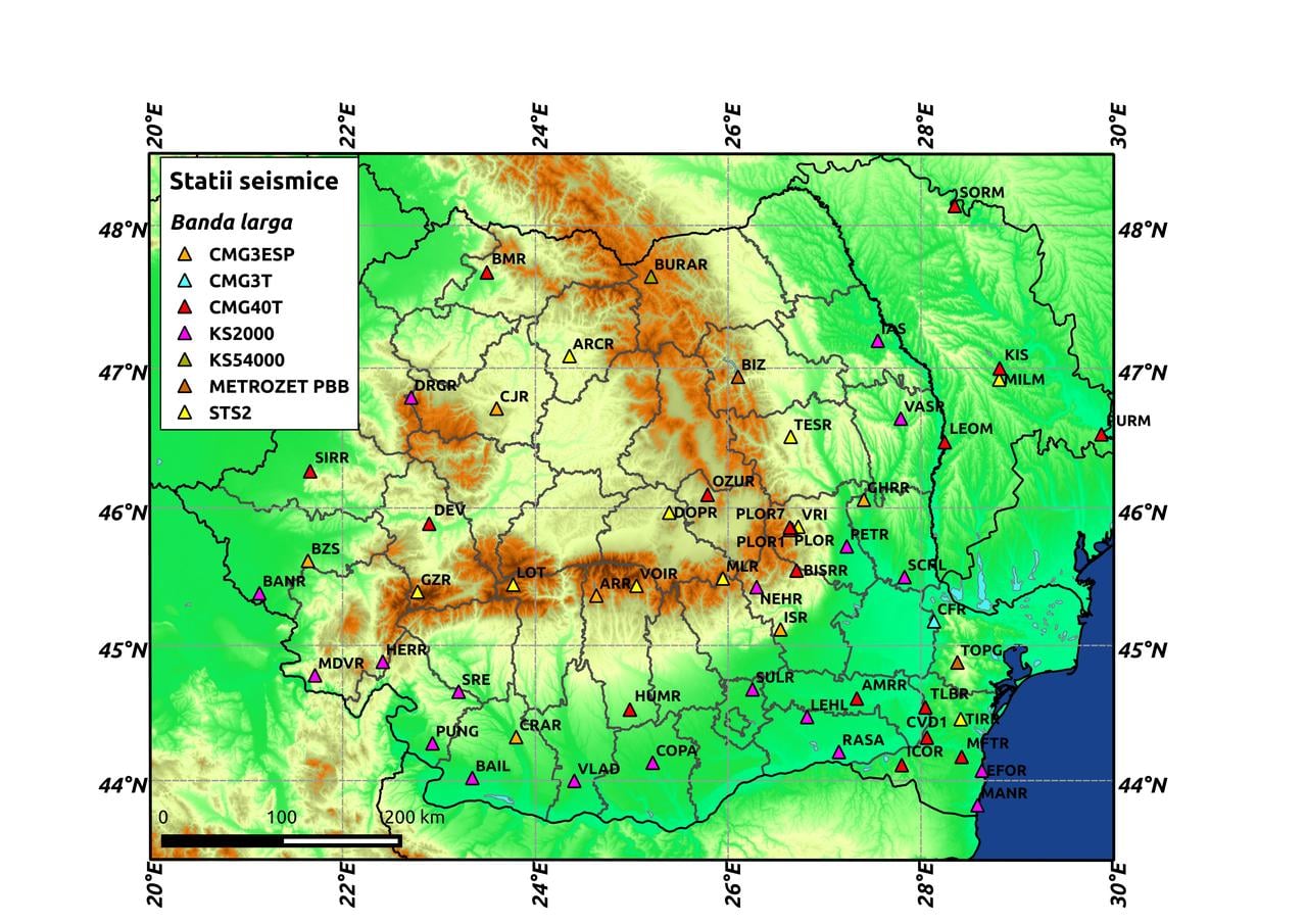
The development of the real-time broadband network began in autumn 2001, when a new monitoring system was installed at Red Mountain (Key) in cooperation with Japan Inernational Agency Cooperation (JICA). The network currently comprises 62 seismic stations equipped with the following types of broadband speed sensors: CMG40T (24), KS2000 (18), STS2 (11), CMG3ESP (5), Metrozet PBB (2), CMG3T and KS54000 (1). It is designed to monitor both small and moderate local earthquakes as well as regional and remote events (teleseism).
Real-time accelerometer network
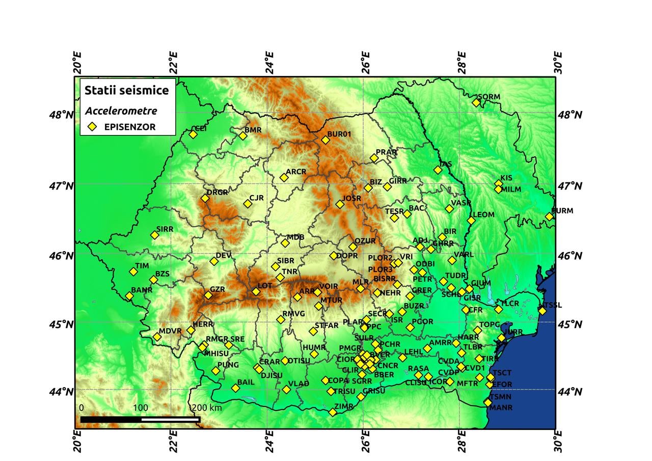
The Accelerometer Network of Romania was born following the cooperation between the INCDFP and the Institute of Geophysics at the University of Karlsruhe. Between 1995 and 1997, 36 digital K2 triggered accelerometers were installed across the country and in Bucharest and surrounding areas of the capital. Currently, the network comprises 102 seismic stations equipped with acceleration sensors (Episenzor) and is designed to monitor strong local earthquakes.
The Accelerometer Network in Bucharest and its surroundings
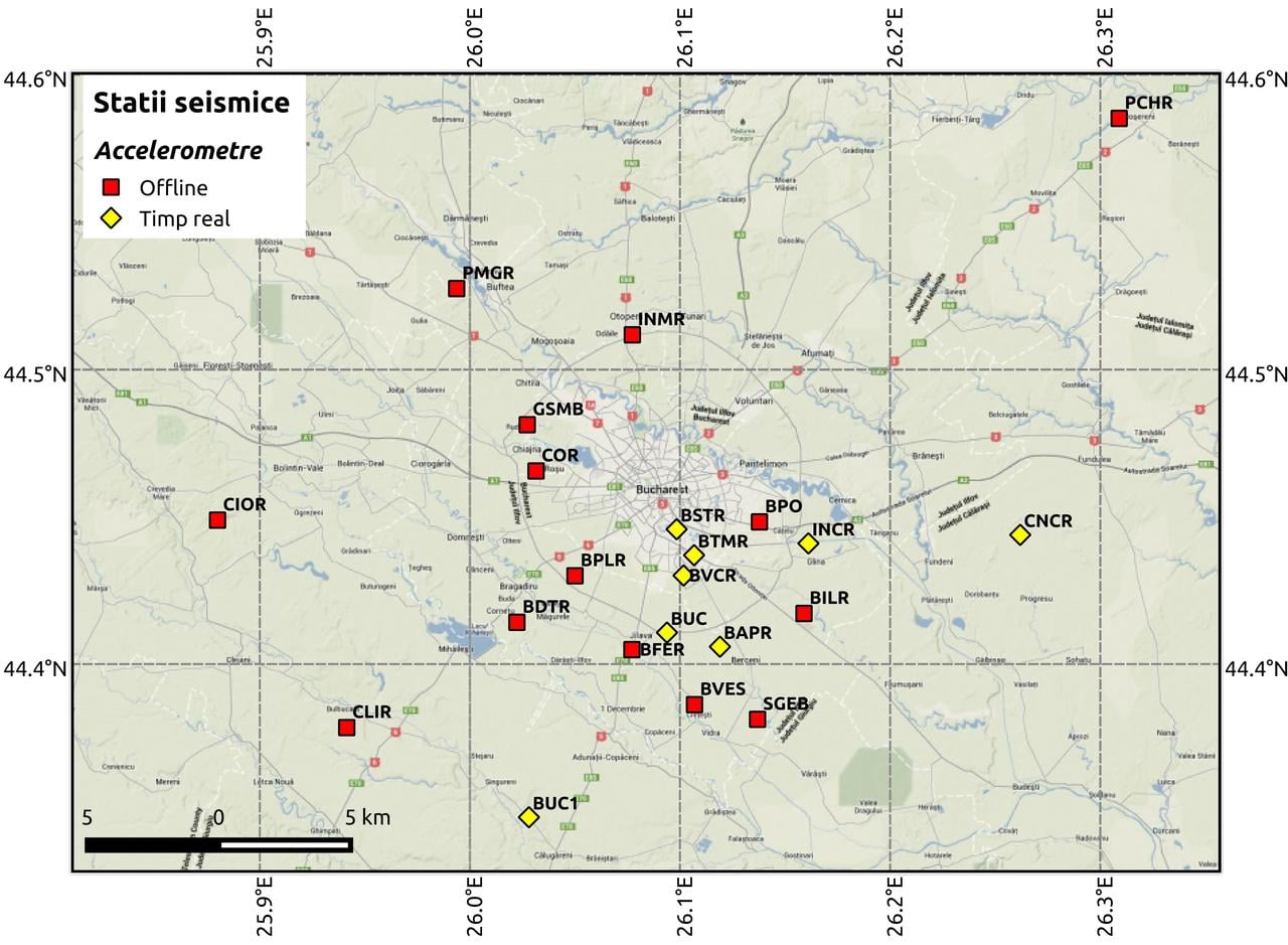
It includes 8 real-time seismic stations and 14 trigger seismic stations equipped with acceleration sensors (Episensor). It is designed to monitor powerful movements.
"Array"-type networks
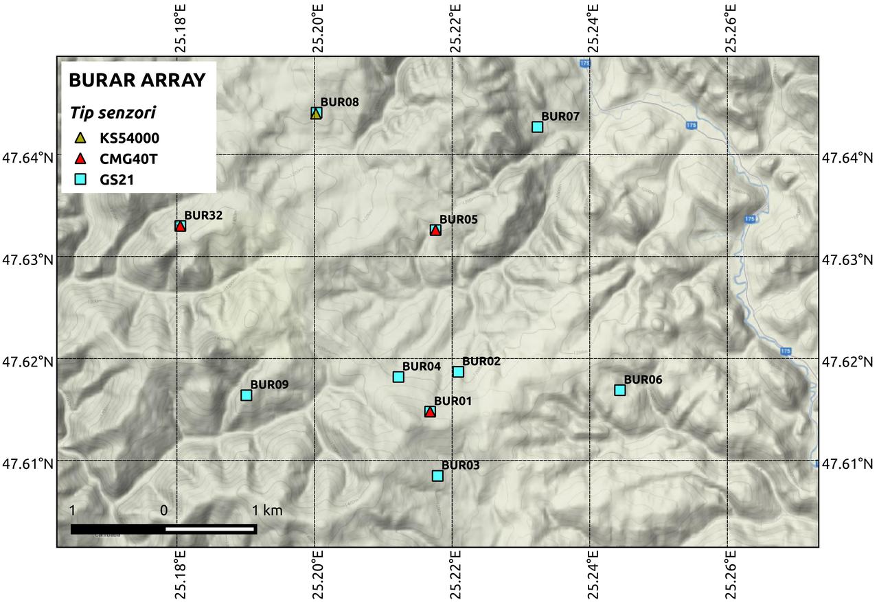
Bucovina "array": The BURAR seismic network consists of 10 stations, equipped with seismic sensors installed in drillings at depths between 30 and 50 m, distributed over a surface of 5 km 2. The new stations (BUR01, ..., BUR09) are equipped with GS21 short-term vertical sensors (Geotech Instruments, USA) and a station (BUR31) is equipped with a KS54000 (Kinemetrics) wideband sensor. Subsequently, in 2008, three other components were installed, equipped with triaxial broadband sensors equipped with Guralp sensors (CMG-40T). Two of them are installed in the same locations as the BUR01 and BUR05 stations at about 1m depth and the 3rd in a different location.
Permanent GPS network
History
The development of the high resolution Global Navigation Satellite System (GNSS / GPS) in Romania for the monitoring of crustal movements was born in 2001 when the first permanent station was located at Lacauti. The network was installed following a strategic partnership between the National Institute of Research and Development for Earth Physics (INCDFP), the Faculty of Geology and Geophysics of the University of Bucharest (FGG), the Technical University of Delft, the University of Utrecht, the Netherlands Research Center for Integrated Earth Sciences (ISES) in the Netherlands and Topgeocart.
Structure
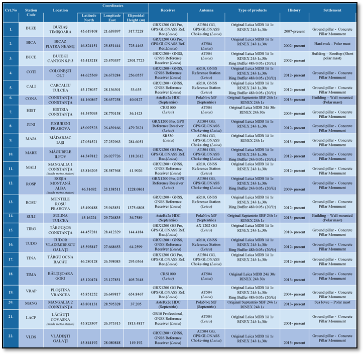
The stations that currently make up the permanent network of INCDFP are presented in the table below.
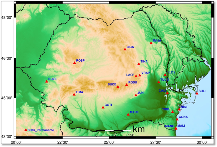
Harta statiilor permanete GPS:
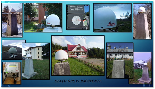
Infrastructure
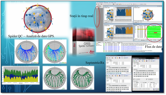
The stations of the NIEP network have mixed equipment, most of them Leica, GRX 1200 GG Pro, GRX 1200 + GNSS and GR10 Professional receivers, and the antenna models used are LEIAT 504, LEIAT 504 GG and LEIAR 10. The network also owns a Leica GX 1230 mobile station with antenna AX 1203 + GNSS. At the same time, three stations operate with Septentrio equipment, AsteRx2HDC receivers and PolaNt-x MF antennas. Data transmission is performed in real time, this being provided by STS (Special Telecommunications Service), GPRS modems, Radiocom and several local providers.
The recordings of frequent frequencies of about 20 Hz of the earthquakes that may occur in the Vrancea area are important data in investigating cose-beam contributions at frequencies above 1 Hz using GPS technology. For this reason, and for carrying out a comprehensive research, 11 of the permanent GPS stations are also provided with accelerometers.
Acquisition, analysis and data processing
Data acquisition is done in real time, in RAW DATA and RINEX format, using the Leica GNSS Spider and Septentrio Rx programs, and the quality analysis is done with the Spider QC program.
In terms of post-data processing, an 1984 agreement was signed between the INCDFP and the Jet Propulsion Laboratory (JPL), an operating division of the California Institute of Technology, on a license to use the GIPSY OASIS NPO - GPS Inferred Positioning System Orbit Analysis and Simulation Software, number 19636. The software is licensed and will be used within the National Seismic Network Laboratory, with the purpose of monitoring crustal deformations using satellite data on Romanian territory. This is the basic software used to achieve data availability over the entire activity of stations, time series and motion vectors. More recently, LGO (Leica Geo Office), GLab (developed by ESA - European Space Agency) and RTKLIB (Open Source Package) were also used.
Monitoring network for magnetotelluric and biosystemic studies
It is well known that there are interconnections between the tectonic activity and the anomalous changes of the geophysical, geochemical and geohidrological parameters that characterize the lithosphere. These changes may reflect some changes that occur in the state of stress at the crust and subcrustal level and could indicate that a critical stress level has been reached. Consequently, different geosynthetic methods attempt to monitor tectonic activity to identify critical regions and stress phases based on earthquake-related precursor phenomena.
The Geophysical Network of the Magnetotelic and Biosystems Studies Association has since 1996 been an exponential development, supported entirely by National and International Research Projects
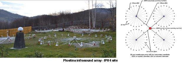
During 2005-2006, the first infrasound monitoring system (IOANE) associated with a wide range of events was built and installed at Plostina. The surveillance of infrasonic acoustic waves propagated through the atmosphere has seen a major development during the Cold War, being used for field tactical surveillance to identify possible sources of such acoustic waves, such as classical and nuclear explosions, rocket launches of various types , displacements of heavy fighting vehicles, helicopters, and planes. Although the range of applicability has remained similar, it has been particularly focused on monitoring nuclear tests, but has expanded on other natural phenomena such as earthquakes, boreal auras formation, boulders passage through the atmosphere, pursuit of tornadoes and others.
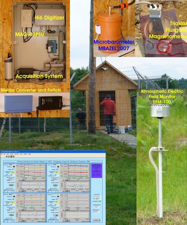
An overview of the PLOR3 location within the Plostina Observatory and some of the equipment involved in the monitoring process: the acquisition system, the MBAZEL2007 microbarometer, the triaxial MAG-03MS fluxgate magnetometer. The EFM-100 electric field monitor is installed in the PLOR4 location near the WS-3600 weather station.
Since July 2006, a comprehensive monitoring system has been designed and set up to provide information on acoustic, electric, magnetic, electromagnetic and weather fields. This system is intended to look for the hidden correlations that may exist between the variations of these fields and the process of preparing the strong intermediate earthquakes in the Vrancea area. Since 2008, NIEP's Magnetoteluric and Biosystemic Studies Association has used in real time a geomagnetic, electrical and infrared monitoring network called MEMFIS - Multiple Electromagnetic Field and Infrasound Monitoring Network, improved by installing the VLF / LF receiver in 2009 and its antennas at the Dobrogea Seismological Observatory
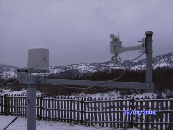
Part of the weather station installed at PLOR4
Fluxgate Magnetometer Installed at Surlari (Spring 2010)
The MEMFIS Network - The Multiple Electromagnetic Field and Infrasound Monitoring Network (Table 1 / Fig.1) is equipped with 4 magnetometers (Bartington) with seismic sensors, 3 inflatable monitoring stations MBAZEL2007, an electrometer for measuring the vertical component of the electric field atmospheric (Boltek EFM100) and a La Crosse WS-3600 meteorological station
MEMFIS geophysical observatories:
| Magnetic Observatory Code |
Equipment |
Lat/Lng |
Altitude (m) |
| MLR |
Seismic/magnetic |
45.49N/25.95E |
1360 |
| SULR |
Seismic/magnetic |
44.68N/26.25E |
97 |
| PLOR2 |
Seismic/magnetic +/-100uT /infras +/-50Pa |
45.8502/N26.6438E |
694 |
| PLOR3 |
Seismic/magnetic +/-100uT /infras +/-50Pa |
45.8539/N26.6455E |
708 |
| PLOR4 |
Seismic/vertical electric +/-20kV/m /infras MBAZEL2007+/-50Pa / infras Chaparal/meteo |
45.8512/N26.6499E |
656 |
| AZEL |
VLF-LF/ meteo/ infras +/-50Pa |
44.3548/N26.0282E |
76 |
| Dobrogea Observatory |
VLF-LF/meteo |
44.0750/N26.6325E |
23 |
Seismo-acoustic network Plostina
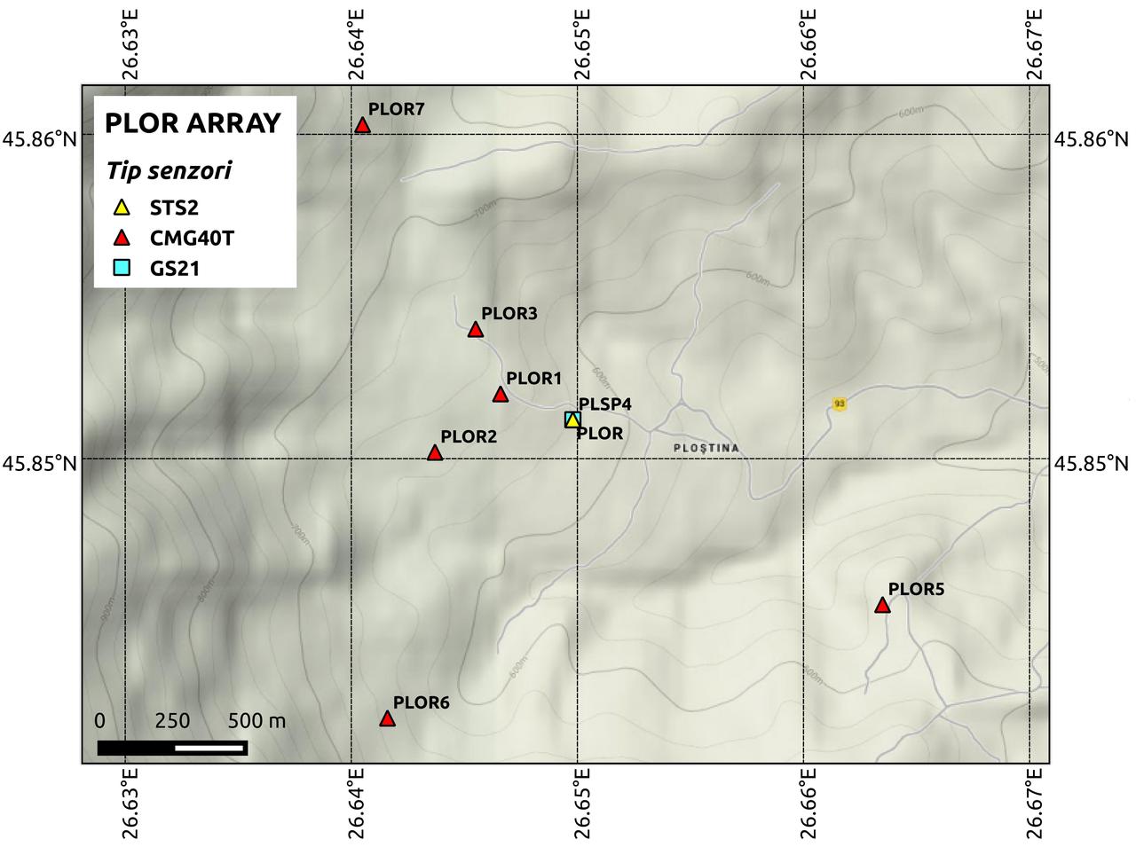
It is an array of 6 elements: IPH2, IPH3, IPH4, IPH5, IPH6 and IPH7.
The central element includes sensors for measuring the electric field and weather conditions.
The data is recorded in real time and stored in the NDC ROM data center in Magurele.
Array elements:
| Element |
Latitude (°N) |
Longitude (°E) |
Altitude (m) |
Depth (m) |
Sensor type |
| PLOR1 |
45.852 |
26.647 |
648 |
3 |
Seismometer 3C BB CGM-40T
Strong motion EpiSensor ES-T FBA |
PLOR2
IPH2 |
45.850 |
26.644 |
647 |
3 |
Seismometer 3C BB CGM-40T
Strong motion EpiSensor ES-T FBA
MicrobarometerChaparral Model 25 |
PLOR3
IPH3 |
45.854 |
26.646 |
665 |
3 |
Seismometer 3C BB CGM-40T
Strong motion EpiSensor ES-T FBA
Triaxial magnetometer MAG-03MS
Microbarometer Chaparral Model 25 |
PLOR4
IPH4 |
45.851 |
26.650 |
616 |
3, 30, 50 |
Seismometers 1C SP GS21, 3C BB STS2
Strong motion EpiSensor ES-T FBA
Triaxial magnetometer MAG-03MS
Microbarometer Chaparral Model 25
Electric field mill Boltek EFM-100
Weather station La Crosse |
PLOR5
IPH5 |
45.842 |
26.642 |
586 |
3 |
Seismometer 3C BB CGM-40T
Strong motion EpisenSor ES-T FBA
Microbarometer Chaparral Model 25 |
PLOR6
IPH6 |
45.846 |
26.664 |
687 |
3 |
Seismometer 3C BB CGM-40T
Strong motion EpiSensor ES-T FBA
Microbarometer Chaparral Model 25 |
PLOR7
IPH7 |
45.860 |
26.641 |
831 |
3 |
Seismometer 3C BB CGM-40T
Strong motion EpiSensor ES-T FBA
Microbarometer Chaparral Model 25 |
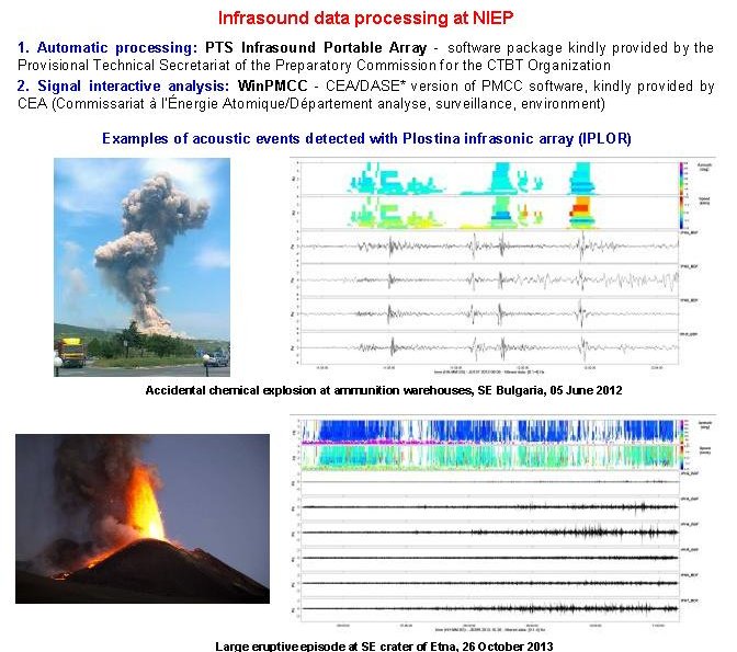
Infrasound Data Processing
Seismic Observatories
Seismological Observatory "Dr. Radu Cornelius" Vrincioaia
The Vrincioaia Seismological Observatory is located in the north-eastern part of the Vrancea epicenter area, aiming to provide data for the seismic alarm system of industrial and civil objects, as well as for the National Seismic Network. was founded in 1942, following the powerful earthquake of 10 November 1940 (magnitude M = 7.4).
Equipped with the Mainka seismograph modified by the Romanian seismologist Demetrescu, he stopped his activity in 1944 because of the war. Between 1952 and 1956 he worked sporadically.
Reopened in 1964, Seismologist Cornelius Radu reopened it in very modest conditions, when, besides the Mainka seismograph, the VEGIK seismograph (Russian photographic apparatus) was installed.
After the earthquake of March 4, 1977 (magnitude M = 7.2) the station equipment was completed with the following systems:
- seismograph KIRNOS (SKM); seismograph DD-1; seismograph SM-3, seismograph S-13, SMA-1 acelerograph.
In October 1980, with its seismograph S13, it became the main station of the seismic data telemetry network in Bucharest.
Thanks to the modernization activity from 1986 to 1989, by building a new building and equipping with new recorders, the Vrincioaia Seismological Observatory becomes one of the reference stations of NIEP.
Seismological Observatory Plostina
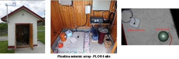
The Seismological Observatory Plostina is located at 8 km N by the Radu Cornelius - Vrincioaia Seismological Observatory and together it forms a scientific research complex designed for the seismic monitoring of the Romanian territory and the measurement of the precursor factors in order to correlate them with the seismic activity and the data supply for seismic alarm system of industrial and civil objectives. Since 2007, an array seismo-acoustic network has been established by installing 4 seismic elements (PLOR1, PLOR2, PLOR3 and PLOR4). In 2009, two more seismic stations (PLOR5 and PLOR 6) were added and the 3-component array infrared network (IPH4, IPH5 and IPH6) was built with the same locations as seismic sensors.
The infrasound network was completed in 2010 by installing the seismo-acoustic element (PLOR7 and IPH7) and in 2012 by installing the IPH 2 and IPH3 seamers. The seismo-acoustic network is installed on an area of 3.5 km2 and the distance between senses varies from 450m to 2450m. At present INCDFP operates an integrated system of technologies: seismic and infrared, acceleration sensors, electro-field monitoring -magnetic, soil temperature measurement, and a weather station. The main applications of the system are: monitoring of local microseismic activity, acoustic measurements (infrasound monitoring of explosions - including those in mines and stone quarries, volcanic eruptions, earthquakes, planes, etc.) observation of magnetic field correlation correlated with solar activity, observation variation of the terrestrial currents.
Dobrogea Seismological Observatory
The Dobrogea Seismological Observatory was inaugurated in 2008 as a back-up for data acquisition and processing at Magurele and as a monitoring center for the tsunami in the Black Sea. The Observatory staff also provides for the maintenance of 10 other seismic stations installed in the region. These stations are equipped with seismometers and accelerometers and the recorded data is transmitted in real time to the CND. Here is also installed equipment for measuring the electromagnetic field and UV radiation.
Seismological Observatory - Rosu Mountain
The Cheia Seismological Observatory - Rosu Mountain is part of the National Seismic Network and contributes data for seismic monitoring in support of the Comprehensive Nuclear-Test-Ban Treaty (CTBTO). The seismic station was included in the auxiliary seismic network of the International Monitoring System (IMS) coordinated by the CTBTO. In order to ensure the participation of Romania in the CTBTO activities and to maintain the seismic station at the operational standards required by the treaty, in 1999 the MLR and NCD seismic stations were modernized, involving technical cooperation with the Government of Japan and technical assistance from the CTBT Organization. The data are continuously recorded and transmitted in real time to CND - Magurele and CID - Vienna.
The station is equipped with both an acceleration sensor and a broadband speed sensor. By its position towards the Vrancea seismic zone, this observatory is one of the most important points of measure in the entire seismic network. In addition to measuring seismic activity, magnetic field masters for earthquake prediction and GPS measurements are also used here. Since 1994, the sesimic station is part of the GEOFON network (Germany).
Bucovina Seismological Observatory
The Bucovina Seismological Observatory (BURAR) consists of a complex seismic network made up of 10 seismic sensors (9 short-period uniaxial (GS-21) and one triaxial broadband (KS 54000)) installed in 30-50 m and distributed over a 5x5 km2 area. The network was installed in 2002, in the framework of the Romanian-American collaboration between the INCDFP and the American Air Force Technical Applications Center. The recorded data is transmitted in real-time by satellite to the National Data Center in Bucharest. In 2007, two broadband 3-C sensors were installed to improve the configuration of the array network in order to record and identify the secondary seismic phases, improve the network response, increasing the sensitivity and resolution of the BURAR network in identifying seismic waves S.
Buzias Seismological Observatory
The Buzias Seismological Observatory, located in Timis County, is part of the National Seismic Network, providing data on the seismicity of the Banloc area. The seismic station is equipped with a broadband sensor.
Deva Seismological Observatory
The Deva Seismological Observatory was established in May 1971, when it was taken into account in the world seismic network for the study of seismicity of the globe, being included in the UNESCO Seismic Network for the Study of Seismicity. It is currently part of the National Seismic Network of Romania, contributing to monitoring the seismicity of the country's territory (especially the Hateg and Banat region). It is equipped with a digital station equipped with broadband and short-range sensors.
Timisoara Seismological Observatory
The Timisoara Seismological Observatory was founded by Prof. Ioan Curea, considered the pioneer of modern seismology in Romania. John Curea reinvigorated the seismic monitoring in Banat and Ardeal, by setting up two seismic stations in Cluj and Timisoara. Thus, in 1939 he founded the Seismic Station Cluj, as a branch of the Astronomical Observatory of the University of Cluj. As a professor at the University of Timisoara, Ioan Curea designed and built two Mainka type horizontal seismographs (m = 540 kg). They were installed in Timisoara in November 1942 at the Astronomical Observatory until 1944. After the war, in 1950, Professor Ioan Curea reactivated the seismic station in a temporary room from the Polytechnic Institute, where he worked until 1965.
References
Mihaela Popa, Mircea Radulian, Daniela Ghica, Cristian Neagoe and Eduard Nastase - Romanian Seismic Network Since 1980 to the Present - Nonlinear Mathematical Physics and Natural Hazards, Chapter 9, , Springer International Publishing, Switzerland, 2014.