Represents a system for the rapid estimation of damage generated by an earthquake in Romania, in terms of affected buildings and socio-economic losses.
Caracteristici
- SEISDARO (version 3) allows the rapid estimation of damage generated by earthquakes ≥ 4.0 ML in Romania and nearby, using two methodologies:
- PAGER: estimates at national level the probability of casualties for a certain severity interval, based on instrumental intensity values and correlations with previous earthquake casualty records.
- SELENA: estimates, at commune/city/sector level, the number of residential buildings affected (more or less) and based on this the number of casualties (from slight injuries to potential deaths) and direct economic losses. The estimation is based on fragility functions for more than 49 representative building typologies (taking into account building material, construction period and height), acceleration values, analytical methods such as I-DCM or MADRS and consequence models. The computation can be adapted also to individual structures, also in conjunction with structural monitoring procedures.
- Both methodologies use as input enhanced exposure data from the Romanian National Census in 2011 and intensity measures and earthquake parameters from REWS or Shakemap systems of INFP, which use data from the stations of the Romanian Seismic Network. Seisdaro also has a custom Shakemap module allowing direct scenario simulation and new methodologies for ground motion estimation.
- Results (maps, graphs and GIS data) are generated, after receiving input data from REWS or Shakemap, in:
- 10-15 seconds (PAGER module)
- 2-3 minute (SELENA module)
- Seisdaro was developed within important research projects (such as DACEA, SERA, TURNkey or RO-RISK), with important contributions from top experts.
Examples of applications
- Assistance in emergency decision making and intervention planning.
- In the elaboration of seismic risk maps (deterministic or probabilistic) and the development of more efficient seismic risk reduction strategies.
- Contribution to risk modelling and business continuity planning, for companies in industry or insurance and reinsurance.
- Adaptation to specific facilities and assets, allowing also for integration with other methodologies (such as the analysis of debris impact or network performance indicators).Adaptation to specific facilities and assets, allowing also for integration with other methodologies (such as the analysis of debris impact or network performance indicators).

Seisdaro Scenario for the SEISM2019 National Exercise, elaborated for a Vrancea earthquake with local magnitude 7.2 at 90 km depth.
Stakeholders relying on Seisdaro
- General Inspectorate for Emergency Situations in Romania (IGSU)
- S.C. OMV PETROM S.A.
- 4 prefectures in Romania, for Defense plans against earthquakes and landslides.
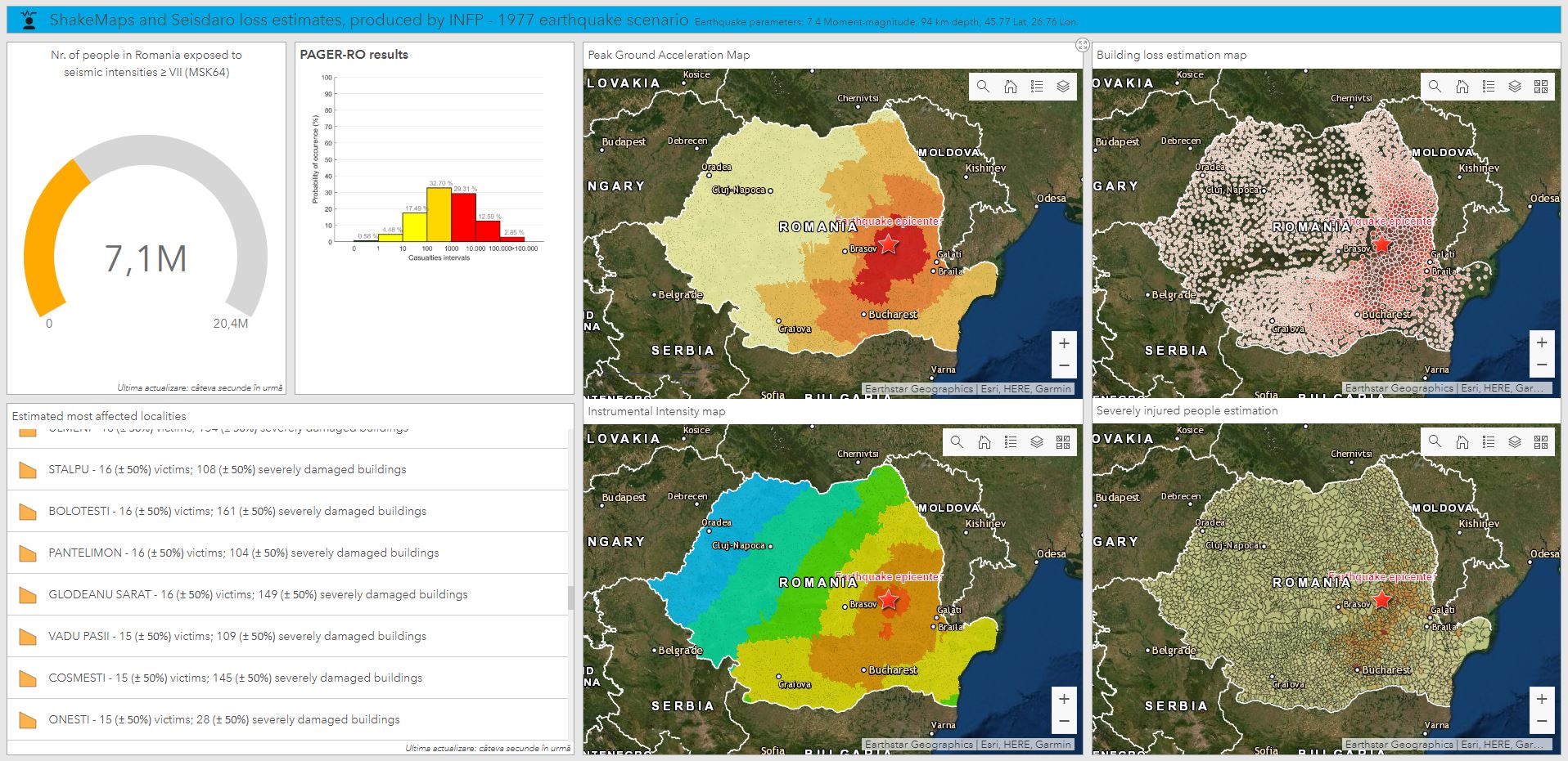
Example of Operational webGIS Dashboard created for a scenario of the 4 March 1977 earthquake (7,4 Mw, 94 km depth), bringing together decision support products from ShakeMap and Seisdaro.
Seisdaro contribution to scientific publications
- Marmureanu A., Ionescu C., Grecu B., Toma-Danila D., Tiganescu A., Neagoe C., Toader V., Craifaleanu I.-G., Dragomir C.S., Meita V., Liashchuk O.I., Dimitrova L., Ilie I. (2021) From National to Transnational Seismic Monitoring Products and Services in the Republic of Bulgaria, Republic of Moldova, Romania, and Ukraine. Seismological Research Letters, 92 (3): 1685-1703, doi: 10.1785/0220200393
- Toma-Danila D., Armas I., Tiganescu A. (2020) Network-risk: an open GIS toolbox for estimating the implications of transportation network damage due to natural hazards, tested for Bucharest, Romania. Natural Hazards and Earth System Sciences, 20(5):1421-1439, doi: 10.5194/nhess-20-1421-2020.
- Toma-Danila D., Cioflan C.O., Ionescu C., Tiganescu A. (2018) The near real-time system for estimating the Seismic Damage in Romania (SeisDaRo) - recent upgrades and results. Proceedings of the 16ECEE (Tessaloniki, Greece)
- Armas I., Toma-Danila D., Ionescu R., Gavris A. (2017). Vulnerability to Earthquake Hazard: Bucharest Case Study, Romania. International Journal of Disaster Risk Science, 8(2):182-195, doi: 10.1007/s13753-017-0132-y.
- Toma-Danila D., Armas I. (2017). Insights into the possible seismic damage of residential buildings in Bucharest, Romania, at neighborhood resolution. Bulletin of Earthquake Engineering, 15(3):1161-1184, doi: 10.1007/s10518-016-9997-1.
- Cioflan C.O., Toma-Danila D., Manea E.F. (2016) - Seismic loss estimates for scenarios of the 1940 Vrancea earthquake (chapter), pp 425-439. In: The 1940 Vrancea Earthquake. Issues, Insights and Lessons Learnt. Proceedings of the Symposium Commemorating 75 Years from November 10, 1940 Vrancea Earthquake. Eds: Vacareanu R. and Ionescu C., Springer Natural Hazards Series, Springer International Publishing, DOI 10.1007/978-3-319-29844-3
- Armas I., Ionescu R., Gavris A., Toma-Danila D. (2016). Identifying seismic vulnerability hotspots in Bucharest. Applied Geography, 77:49-63, doi: 10.1016/j.apgeog.2016.10.001.
- Toma-Danila D., Zulfikar C., Manea E.F., Cioflan C.O. (2015). Improved seismic risk estimation for Bucharest, based on multiple hazard scenarios and analytical methods; Soil Dynamics and Earthquake Engineering, 73:1-16, doi: 10.1016/j.soildyn.2015.02.013.
- Toma-Danila D., Cioflan C.O., Balan S.F., Manea E.F. (2015). Characteristics and results of the near real-time system for estimating the seismic damage in Romania, Mathematical Modelling in Civil Engineering, Vol. 11, No. 1, pp. 33-41
- Toma-Danila D. (2012). Real-Time Earthquake damage assessment and GIS analysis of two vulnerable counties in the Vrancea Seismic Area, Romania; Environmental Engineering and Management Journal, 11(12):2265-2274.
For a detailed offer and collaboration proposals, contact us at: contact[_at_]infp.ro or +40722698438
DOWNLOAD THE PDF BROCHURE